

    {
      "variants": [{
            "id": 42772564050082,
            "selected": false,
            "sku": "8168508",
            "inventory_quantity": 0,
            "inventory_policy": "deny",
            "option1": "Default Title",
            "option2": "",
            "option3": "",
            "price": "29900",
            "compare_at_price": null,
            "swymData": {
  "empi": 7712701939874,
  "epi": 42772564050082,
  "pr": 299.0,
  "du": "https://www.biasboating.com.au//products/bluechart-g3-vision-microsd-port-stephens-fowlers-bay?variant=42772564050082",
  "iu": "\/\/www.biasboating.com.au\/cdn\/shop\/products\/8168508_620x620.jpg?v=1666848379"
}
,
            "metafields": {}
          }],
      "productOptions": [

          {
            "name": "Title",
            "available": [

                "Default Title"


            ]
          }

      ],
      "default_variant": true,
      "settings": {"invalid_text":"The selected options are not available together, please adjust your selection","unavailable":"Unavailable","select_option":"Please select an option","select_variant":"Please choose a variant"},
      "product": {
        "price": "29900",
        "compare_at_price": ""
      }
    }
Our Premium Chart Offering
- Derived from official charts and private sources to provide navigational aids, spot soundings, depth contours, tides and currents, and detailed harbors and marinas
- Garmin Auto Guidance technology shows a suggested route to a destination¹
- Depth Range Shading for up to 10 depth ranges enables you to view your target depth at a glance
- Up to 1-foot contours provide a more accurate depiction of the bottom structure for improved fishing charts and navigation
- Shallow Water Shading feature allows for depth shading at a user-defined level to aid in navigation
- Unique 3D views like MarinerEye and FishEye provide additional perspective both above and below the water line
- High-resolution satellite imagery of ports, marinas, bridges and navigational landmarks for superior situational awareness
- Worldwide coverage available
- Keep your charts up to date with our industry-leading New Chart Guarantee and discount card update program
Auto Guidance¹
Auto Guidance technology quickly calculates a suggested route using your boat's dimensions and a suggested path to follow.
High-resolution Relief Shading
This exceptional shading feature combines color and shadow to give you an easy-to-interpret view of bottom profile, making it easy to find artificial reefs, underwater shelves and more. High-resolution relief shading is available as a free downloadable feature via the ActiveCaptain® app.
Depth Range Shading
Displays high-resolution Depth Range Shading for up to 10 depth ranges so you can view your designated target depth.
Detailed Contours
BlueChart g2 Vision HD features 1-foot contours that provide a more accurate depiction of bottom structure for improved fishing charts and enhanced detail in swamps, canals and port plans.
MarinerEye View
Provides a 3-D representation of the ocean floor as seen from below the waterline.
FishEye View
Provides a 3-D representation of the surrounding area both above and below the waterline.
High-resolution Satellite Imagery
High-resolution satellite imagery with navigational charts overlaid gives you a realistic view of your surroundings so you can navigate with a clear moving-chart representation of your boat’s position. It’s our most realistic charting display in a chartplotter.
Aerial Photography
Crystal clear aerial photography shows exceptional detail of many ports, harbors and marinas and is ideal when entering unfamiliar ports.
BlueChart Feature Comparison
¹Auto Guidance is for planning purposes only and does not replace safe navigation operations
²Raster cartography is available for selected countries. It cannot be viewed on echoMAP CHIRP and ECHOMAP Plus combos but can be viewed on mobile devices via the ActiveCaptain mobile app
Download Requirements
The file size of this download and space required on your microSD™/SD™ card is 0 MB. It is not recommended that this download be loaded directly to your device. It only can be loaded to a prepared or blank microSD/SD card (recycled microSD cards may be used to program map data).
Up to 500 MB of additional space may be required for software updates.
microSD™/SD™ Requirements
Coverage

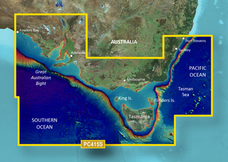
Detailed coverage of the Southeastern coast of Australia from Port Stephens to Fowlers Bay. Also includes detailed coverage of Sydney, Flinders and King Islands, Tasmania, Melbourne, and Adelaide.
After ordering online, you will receive an automated email confirmation containing your order details. Your order will then be confirmed within a few minutes of placing your order.
It is our policy to ensure we deliver to our customers in a timely manner. In order to achieve this we use a range of freight companies depending on the size and weight of your order. In some instances we may use a number of carriers to get your products to you. For example, chain may come by road, some electronic equipment by air.
Most orders are shipped within 2 - 5 Days
Shipping rates
Orders delivered to Australian Post Codes attract an $18.00 Flat Rate Shipping Charge* This excludes Bulky or Dangerous Goods
For Bulky Goods, Dangerous Goods and Remote areas.
If the cost to send is vastly different to our standard delivery costs, someone from our team will contact you prior to dispatch to arrange further payment or to issue a refund if you are not happy with the additional charges.
International orders will be charged at $0.00 initially and our staff will be in contact with a shipping quote. If the quote is not accepted the customer reserves the right to cancel their order and be refunded in full.
Should you have any queries or concerns about shipping, please don't hesitate to get in touch by clicking the support button on bottom right of the page.
Others Also Viewed
$18 Flat Rate Shipping
Excludes Bulky/Dangerous Goods
Satisfied or Refunded
Love it or not entirely satisfied with your order? Let us know!
Top-Notch Support
Any questions? Our team is one click away!
Secure Payments
Your payment information is processed securely.


