


    {
      "variants": [{
            "id": 42773134606498,
            "selected": false,
            "sku": "8171175",
            "inventory_quantity": 0,
            "inventory_policy": "deny",
            "option1": "Default Title",
            "option2": "",
            "option3": "",
            "price": "1289900",
            "compare_at_price": null,
            "swymData": {
  "empi": 7712863715490,
  "epi": 42773134606498,
  "pr": 12899.0,
  "du": "https://www.biasboating.com.au//products/gpsmap-r-8417-mfd-w-worldwide-basemap?variant=42773134606498",
  "iu": "\/\/www.biasboating.com.au\/cdn\/shop\/products\/010-01510-00_620x620.png?v=1666859565"
}
,
            "metafields": {}
          }],
      "productOptions": [

          {
            "name": "Title",
            "available": [

                "Default Title"


            ]
          }

      ],
      "default_variant": true,
      "settings": {"invalid_text":"The selected options are not available together, please adjust your selection","unavailable":"Unavailable","select_option":"Please select an option","select_variant":"Please choose a variant"},
      "product": {
        "price": "1289900",
        "compare_at_price": ""
      }
    }
SERIOUS CRUISERS, SAILORS AND SAIL RACERS DEMAND SERIOUS EQUIPMENT
The large-format multifunction display (MFD) lets you experience a beautifully powerful, completely networked helm at your fingertips.
- Premium 17” full HD touchscreen display has the highest resolution on the marine market.
- Easily build your marine system using the best of network connectivity.
- From ANT® technology to Wi-Fi® networking, there are countless ways to connect to your system.
- Take the guesswork out of sailing with clear laylines and more — right on the screen.
- With SmartMode™ station controls, everything is designed to give you quick, one-touch access to the information you need.
- It’s compatible with premium maps and charts for the best in Garmin mapping with Navionics data.
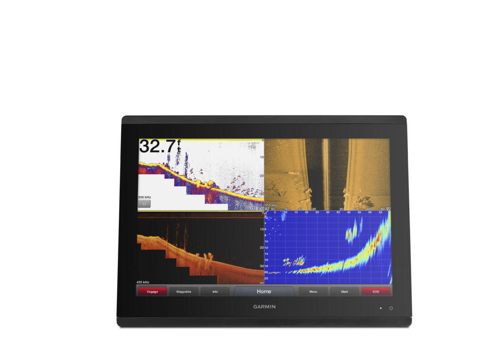
GPSMAP 8417 large-format multifunction display features a 17-inch full HD screen with touch control. Sunlight-readable, anti-glare display is exceptionally easy to view and also includes auto-dimming feature for use in low light or at night. New maximum glass design enables you to experience a beautifully powerful, completely networked helm at your fingertips. In-plane switching (IPS) LCD display — an industry first for this class — provides consistent, accurate colors from all viewing angles. It also provides standard USB touch output for use as a touchscreen monitor for Windows® and Mac® operating systems. Install multiple displays with the industry’s lowest flush-mount profile or flat mount them edge-to-edge to create a sleek glass helm look. Quick, 1-touch access to the information you need makes boating easier.
Full System Integration
GPSMAP 8417 integrates various sonar technologies as well as autopilot, connectivity, apps, engine data and multi-media. User data can be automatically synced for all networked networked 8400/8600 series chartplotters across multiple helms — everything you need is at your fingertips, all on 1 screen. A full digital switching system uses CZone technology. You can power up your boat while away from the dock, switch on pumps and control lights — even underwater lights. Nearly all of your controls are available right at your fingertips either at the helm or programmed into a remote key fob or an app on your tablet provided by CZone by Mastervolt.
New High-performance Processor
Experience the fluidity of our fastest map drawing ever and enhanced video processing. Add up to 4 IP camera streams and simultaneous Garmin Helm™ support. In addition, all your added sensors, such as radar, sonar, multimedia and more, will benefit from the increased performance to provide a premium experience across your boat’s entire network.
Customize Layouts with SmartMode™ Control
To make boating easier, GPSMAP 8417 includes presets for sonar, radar, cameras, media and digital switching, which can be independent or incorporated into SmartMode. With SmartMode control, you can quickly change all screens at a helm in sync to a preset mode, for example, fishing, docking, night cruising, etc. One-touch access allows you to switch all monitors in sync from 1 mode to another without manually switching each monitor separately. Fully customizable layouts, data and gauges allow you to place the information you need to see right where you want it.
Garmin Marine Network and NMEA 2000® Network Support
Full-network compatibility allows you to add more to your boat. GPSMAP 8417 supports radar, autopilot, instruments, multiple screens, FUSION-Link™ entertainment system, sensors, remote sonar modules, digital switching, weather, thermal cameras, GRID™ remote device and more. It’s also FLIR camera compatible and provides SiriusXM support.
View Multiple Sonar Sources Simultaneously
GSD™ 26 CHIRP professional sonar, GSD 24 advanced sonar, and GCV™ 10 or GSD 25 DownVü and SideVü scanning sonar, even Garmin Panoptix™ all-seeing sonar, can exist on the same system. You can view various sonars together on 1 monitor or across multiple monitors in multi-display systems.
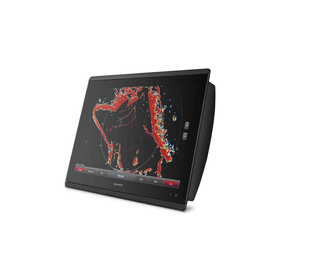
Add Array or Dome Radar
You can add your choice of Garmin marine radar, including our powerful xHD2 open-array radars, GMR Fantom™ open-array radars with MotionScope™ technology or xHD dome radars that pair ease of use with advanced open-array features.
Network Sharing
GPSMAP 8417 allows you to share features with other compatible GPSMAP units such as radar, supplemental maps and user data, including waypoints, routes and tracks. You can also share images from Garmin VIRB® action cameras, GC™ 10 marine cameras and FLIR cameras. User data entered into 1 chartplotter can be automatically synced with other chartplotters in a network.
Heading, Position Refreshed 10 Times per Second
Fast, responsive built-in 10 Hz GPS refreshes your position and heading 10 times each second to make your movement on the screen more fluid. Now, it’s quick and easy to drop up to 5,000 accurate waypoints and find your way back to them.
SailAssist Features
Supported sailing features include laylines, enhanced wind rose, heading and course-over-ground lines, true wind data fields and tide/current/time slider. Racing features include pre-race guidance, synchronized race timer, virtual starting line, time to burn and layline data fields. Gauge displays are designed to provide important, need-to-know information at a glance, including true and apparent wind angle, set and drift, true or apparent wind speed, horizontal or vertical graphs and a data bar with customizable data fields.
Create Your Own HD Maps
Quickdraw Contours is a free, easy-to-use software feature that is already installed on your GPSMAP 8417. It instantly creates your very own personalized HD fishing maps with 1-foot contours. Tailor them to fit your needs. They are your maps. You own them. Keep the data to yourself or share it with Garmin or your friends. There’s no special surveying expertise required. You just fish while it creates maps. You don’t have to wait around or send your files away like other mapping software requires — your results appear instantly. Use with any Garmin Panoptix, any HD-ID™, any CHIRP-enabled, Garmin DownVü™ transducer or NMEA 2000-compatible depth transducer. Have more than 1 sonar device installed onboard? Quickdraw Contours automatically selects the most capable sonar device to provide the very best results for you!
Upgrade to Our Best Maps on the Water
Add a Garmin Card Reader that provides convenient remote mounting and a single access point for 2 SD™ card slots for accessory map purchases such as BlueChart g2 HD or BlueChart® g2 Vision® HD, which add Garmin-patented Auto Guidance 3.0 and other great features. You can add multiple card readers for additional access points. Waterproof magnetic door allows card reader to be mounted horizontally or vertically (sold separately).
FUSION-Link Entertainment System
Enjoy the ability to control all compatible FUSION-Link-enabled audio systems directly from your compatible chartplotter display.
Built-in Connectivity
It’s easy to connect to peripheral devices with built-in Wi-Fi® connectivity, ANT® technology, 4 wired Ethernet ports, NMEA 2000, HDMI and USB ports with complete network compatibility. It’s easier than ever to enjoy the full range of features provided by Garmin Helm and BlueChart® Mobile apps.
View, Control Your Device from a Smartphone or Tablet
Garmin Helm allows you to view and control your compatible chartplotter from a compatible smartphone or tablet while providing enhanced situational awareness for the mariner. Easily switch between portrait and landscape modes to accommodate mounting preferences. When using an iPhone® or iPad®, you can even record a movie of your chartplotter screen to share with friends and family.
Get Onboard with BlueChart Mobile
With BlueChart Mobile 2.0, a free app downloaded from the App Store™, you can get reliable weather information while you plan marine routes on your iPad or iPhone then wirelessly transfer them to your boat’s compatible networked Garmin chartplotter. Continue to acquire current weather information from your cellular-based Apple® device, and stream that data onto your chartplotter screen. Even if you don’t have a Garmin chartplotter, you can still take advantage of the tremendous features of BlueChart Mobile on your compatible Apple device.
Multiple Depth Range Shading
Designate up to 10 different depth ranges each with its own color. Makes it easier to view target depths at a glance.
Commission Autopilot from Chartplotter
To make commissioning easier and more convenient, you can handle the entire autopilot commissioning process from your chartplotter screen.
In The Box:
- GPSMAP 8417
- Trim piece snap covers
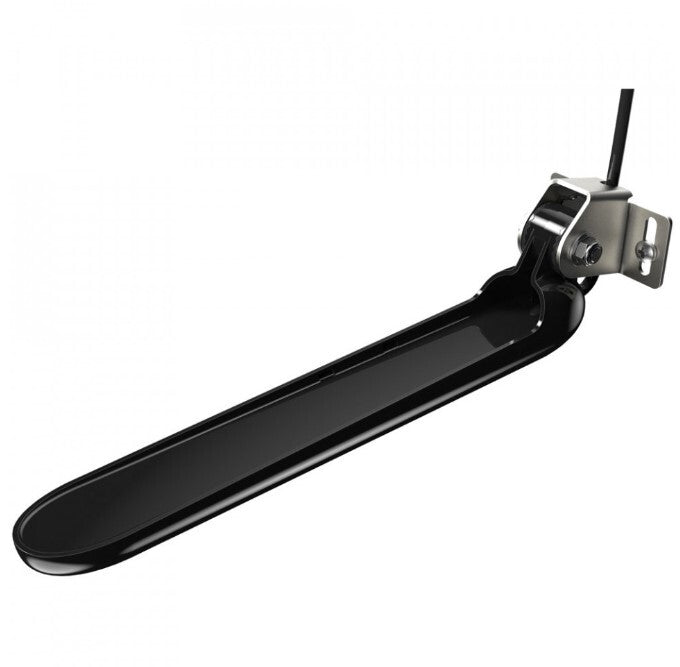
- GPS 24xd NMEA 2000 (with pole mount, flush mount and under deck mount adapters)
- Protective cover
- Flush mount hardware
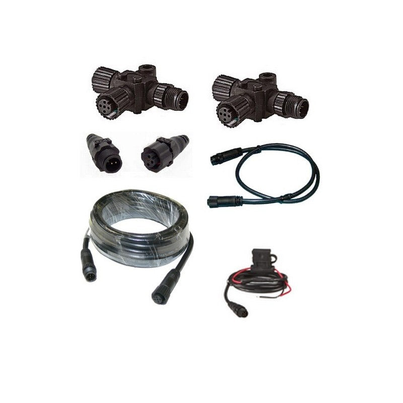
- Power cable
- NMEA 2000 2 m backbone/drop cable
- NMEA 2000 6 m backbone cable
- NMEA 2000 power cable
- NMEA 2000 T-connector & terminator kit
- Documentation
General
| Physical dimensions | 16.5" x 12.1" x 2.8" (41.9 cm x 30.7 cm x 7.1 cm) |
|---|---|
| Water rating | IPX7 |
| Mounting options | Flush or Flat |
| Antenna | External only |
| Receiver | 10 Hz high-sensitivity |
| Display size |
14.4" x 9.1"; 17.0" diagonal (36.6 x 23.1 cm; 43.2 cm diagonal) |
| Display resolution | 1920 x 1200 pixels |
| Weight | 11.48 lbs (5.21 kg) |
| Display type | touchscreen IPS display (anti-glare finish) |
| Power Consumption | Max power usage at 10 Vdc: 40 W |
| Transmit Power | 1 kW traditional; 1 kW CHIRP |
| Polarised Support | ✓ |
| Garmin Marine Network Ports | 4 |
Maps & Memory
| Accepts data cards | 2 SD Cards (with Garmin SD card reader accessory) |
|---|---|
| Preloaded Maps | None |
| Waypoints | 5,000 |
| Track log | 50,000 points; 50 saved tracks, with 5000 points each |
| Routes | 100 (250 waypoints each) |
Outdoor Recreation
| Tide Tables | ✓ |
|---|
Chartplotter Features
| Garmin Radar Compatible | ✓ |
|---|---|
| Garmin Sonar Compatible | Yes |
| Garmin SmartMode Compatible (customizable monitor pre-sets) | ✓ |
| Supports AIS (Tracks Target Ships Position) | ✓ |
| Supports DSC (Displays Position Data From DSC-Capable VHF Radio) | ✓ |
| Supports Fusion-Link Compatible Radios | ✓ |
| GSD™ Black Box Sonar Support | ✓ |
| GCV™ Black Box Sonar Support | ✓ |
| ActiveCaptain Compatible | ✓ |
Sonar Features & Specifications
| Dual-Frequency (50/200 KHZ) Sonar Capable | Yes (with external black box, sold separately) |
|---|---|
| Dual-Beam (77/200 KHZ) Sonar Capable | Yes (with external black box, sold separately) |
| ClearVü | Yes (with GCV™ black box, sold separately) |
Connections
| NMEA 2000® Compatible | ✓ |
|---|---|
| NMEA 0183 Input Ports | 4 |
| NMEA 0183 Output Ports | 2 |
| Wireless Connectivity | Yes |
| Additional |
Additional connections:
HDMI and composite video inputs are encoded and shared across the Garmin Marine Network to other comaptible chartplotters. |
|---|
After ordering online, you will receive an automated email confirmation containing your order details. Your order will then be confirmed within a few minutes of placing your order.
It is our policy to ensure we deliver to our customers in a timely manner. In order to achieve this we use a range of freight companies depending on the size and weight of your order. In some instances we may use a number of carriers to get your products to you. For example, chain may come by road, some electronic equipment by air.
Most orders are shipped within 2 - 5 Days
Shipping rates
Orders delivered to Australian Post Codes attract an $18.00 Flat Rate Shipping Charge* This excludes Bulky or Dangerous Goods
For Bulky Goods, Dangerous Goods and Remote areas.
If the cost to send is vastly different to our standard delivery costs, someone from our team will contact you prior to dispatch to arrange further payment or to issue a refund if you are not happy with the additional charges.
International orders will be charged at $0.00 initially and our staff will be in contact with a shipping quote. If the quote is not accepted the customer reserves the right to cancel their order and be refunded in full.
Should you have any queries or concerns about shipping, please don't hesitate to get in touch by clicking the support button on bottom right of the page.


$18 Flat Rate Shipping
Excludes Bulky/Dangerous Goods
Satisfied or Refunded
Love it or not entirely satisfied with your order? Let us know!
Top-Notch Support
Any questions? Our team is one click away!
Secure Payments
Your payment information is processed securely.